CILLITEC UAV-DRONE

CILLITEC UAV-DRONE

martedì 29 luglio 2014

Take off & land anywhere: Russia unveils hybrid amphibious drone vehicle

Take off & land anywhere: Russia unveils hybrid amphibious drone vehicle

Chirok amphibious UAV

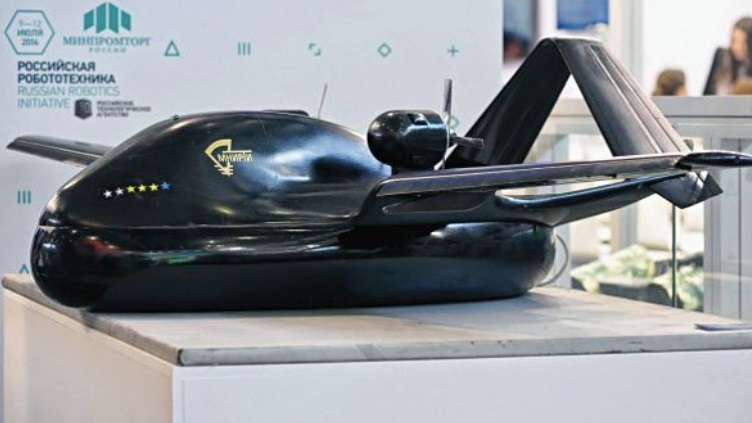
A drone hybridized with an amphibious hovercraft has been presented at the Innoprom-2014 technology exhibition in Russia’s Yekaterinburg. This unique UAV doesn’t need an airfield to launch, so the only alternative is a helicopter.

Russia’s Rostech state corporation presented the first-ever drone that can land on any terrain, whether hummocky land, loose snow, sand, water, or swampland – any relatively flat surface will do.

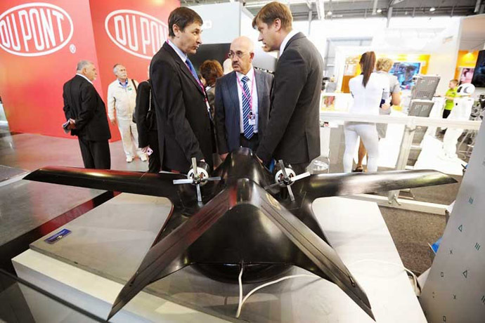
The aircraft dubbed Chirok (Teal) is both an unmanned aerial and amphibious vehicle; it was developed by Rotech’s branch, Integrated Instrument-making Corporation (IIC).

“There is only one alternative to this aircraft [Chirok] – a helicopter,” Aleksey Smirnov, the head of the unmanned aerial vehicles department at Radio-Technical Institute, told the OTV channel.

The 1:5 Chirok prototype presented at the exhibition has been specifically made to test its aero performance in a wind tunnel.

In 2015, the full-scale Chirok aircraft will start flight tests. It will have a wingspan of 10 meters and have a maximum takeoff mass of approximately 700 kilograms, of which 300kg would be its effective payload.

Photo from rostec.ru
With 6,000 meters of altitude ceiling, the UAV is expected to travel up to 2,500 kilometers on a single fuelling. Information about the Chirok’s propulsion is classified.

The ‘aircraft-hovercraft’ is made exclusively of composite materials, while the fabric of its air cushion was developed in Russia and is patented by the Rostech Corporation. The air cushion is fully retractable in flight mode.

Photo from rostec.ru
Though the drone will most likely be used for reconnaissance and wild fire monitoring missions, delivery of necessities to distant oil rigs etc., its construction also enables carrying assault military appliances.

The Chirok could be equipped with high precision weapons, such as small-size guided missiles. Unlike most existing UAVs, the Chirok has enough inner space to fit the weapons internally, so that under-wing missiles won’t interfere with aerodynamics and landing. Because the aircraft is of moderate size and made of composites, it also has excellent stealth characteristics.

It is expected that at Moscow-hosted MAKS-2015 air show UAV Chirok will be presented as an operable prototype. Production of the aircraft could be started as early as 2016.

Photo from rostec.ru


FONTE:Take off & land anywhere: Russia unveils hybrid amphibious drone vehicle | sUAS News

lunedì 28 luglio 2014

seL4 Secure Micro kernel


seL4 Secure Micro kernel


"A nippy microkernel mathematically proven to be bug free*, and used to protect drones from hacking, will be released as open source tomorrow."


Has anyone heard about or seen this? How applicable is this to the Pixhawk, Pi or BeagleBone flight controller efforts? The best bit is that it seems to assure that all user mode code execution is isolated from the Kernel in such a way as to prevent crashing the kernel. I don't think this actually prevents bad FC code but it sounds like it could be a step in the right direction surely.


Without reading too much into this I did note that in the video they seem to say that the software "detects" malicious groundstations by monitoring for those that attempt to authenticate with the wrong password too many times. They also said that the GCS link was encrypted. I think what they actually mean is that their software overlays encryption to MAV connections and the FC detects attempts to communicate over unencrypted links. I'd hate for this to be another WEP style weak cipher that encrypts with a shared key or worse still some kind of authenticated SSL style link using a password based challenge response in each conversation


More details here


fonte:seL4 Secure Micro kernel - DIY Drones

mercoledì 23 luglio 2014

DroneLogbook on iPad

iPad version of DroneLogbook is available today.

https://itunes.apple.com/gb/app/drone-logbook/id896271911?mt=8&...

You can now manage all your data : flights, drones, equipments and maintenance, offline on your iPad and sync easily with the server to backup and review data on the website (http://www.drone-logbook.com).

Have great flights!

DroneLogBook team.


fonte:DroneLogbook on iPad - DIY Drones

ObliX: multirotor-blimp-drone


I am very excited to present ObliX to you! ObliX is my multirotor-blimp-drone idea, which will hopefully combine the flight time endurance of a blimp with the agile dynamics of a quadcopter.


The largest dimension of this hybrid-blimp would measure about 3 m and the lifting force of the helium volume would be close to 3 kg.

Starting to build ObliX, I decided to make a development blog about it. To be able to present and discuss the progress in just the way I like, I thought it might be a good idea to make my own website for it. So here it goes:


http://danielwibbing.wix.com/oblix


It would be awesome if you would have a look at my website and support the develop ObliX with your comments. Maybe you would even like to become a member of the development team? Go ahead and contact me!


 fonte:ObliX: multirotor-blimp-drone - DIY Drones

RPAS Logger Lite for Android – Another logbook for your UAV’s

RPAS Logger Lite for Android – Another logbook for your UAV’s


In the interests of sharing .... RPAS Logger Lite for Android – Another logbook for your UAV’s

RPAS Logger Lite is built to support all companies and pilots flying a Remotely Piloted Aircraft (RPA) as a hobby or for commercial activities to establish a safety culture and also record the information required to maintain government compliance.

  RPAS Logger


 fonte:RPAS Logger Lite for Android – Another logbook for your UAV’s - DIY Drones

The issues with current multirotors and how we want to fix them

The issues with current multirotors and how we want to fix them


Hi everyone! My name is Jonathan Parrott, and I’m with Stephen Dade and James Pattison. We are all members of the CanberraUAV non for profit organisation from Australia and between us have been involved with “drones” for over 13 years between us.
We love multirotors, and have bought and/or built A LOT of them between us, only to be let down by one thing or another. Lazy and unsafe design compromises, poor build quality, substandard gimbals, and poor/illegal video transmitters are just the start of the issues we keep coming across.  We saw a need to fix these problems, so we created the UASys (Uninhabited Aircraft Systems) team. We are focused on designing and creating safe and innovative multirotors with particular emphasis on safety, practicality, aesthetics, and high quality video feeds.

It helps that James is an aerospace engineer (and a bit crazy). Stephen is a communications engineer (and assists with the APM:Planner 2 Linux port, MAVProxy development AND runs the occasional quadcopter workshop). Lastly I (just call me Jono) work as an aviation traffic management officer (yeah it’s kinda complicated to explain).  So all in all a pretty good set of skills to attack this kind of project with.

We are all massive fans of open source software, and think that not only the final product, but the journey, should be open to all. We're really excited to get started on some concepts and an initial prototype and will keep everyone updated with how we are going!


We've got a few more concept pictures on our Flickr page so check it out :)


fonte:The issues with current multirotors and how we want to fix them - DIY Drones

Yet another Flight Control Board


Encouraged by the success of my previous custom board (Version 2), which happily carries my quad in the air (maiden flight) with some advanced features like self-stabilization, course lock, control loop operating at 400 Hz, etc., I decided to jump on a more ambitious project - the board with more sensors, more ports, etc.

In summary, the new board (Version 3) has the following parameters:

  • PIC24EP512GP806 MCU operating at 64 MHz;
  • Two MPU-6050 sensors (in the hope to achieve better vibration rejection);
  • New HMC-5983 magnetometer;
  • MPL3115A barometric altimeter that can be configured to report altitude instead of the raw pressure;
  • On-board 3.3V 1A voltage regulator;
  • 8 PWM ports for quad-, hexa-, and octo-copters and/or quad and camera control;
  • 4 UART ports for GPS, US-100 ultrasonic sensor, UART-enabled RC receiver, and Data Logger;
  • ICSP port for programming;
  • On-board signal LED and header for connecting external LED or buzzer (powered through MOSFET);
  • Standard size with mounting holes matching KK and MultiWii boards.
Here is the board overview (above)

I will be documenting every step of developing (mostly - porting from V2) firmware for this boards as well as sensors' calibration on my blog. Obviously, all the code is Open Source under the MIT License located in the SVN repository.


fonte:Yet another Flight Control Board - DIY Drones

Kickstarter project for quadcopter-based hoverbike

Kickstarter project for quadcopter-based hoverbike


Gizmag reports on the launch of a new Kickstarter project that uses quadcopter design to lift humans. (me, I think if men were meant to fly they'd have wings. That's what robots are for!)

Having revealed its original Hoverbike design back in 2011, Malloy Aeronautics has been hard at work developing its ambitious, science fiction-inspired vehicle. The team has made some significant changes in the last few years, moving from a dual rotor to quad rotor design while adding some serious stability credentials in the process. Chris Malloy has now launched a crowdfunding campaign on Kickstarter where backers are being offered a working one third scale version of the second-generation Hoverbike, while giving the team a helping hand in the development of the eventual, manned vehicle.

The hoverbike has been a staple of science fiction for decades, but it’s only in recent years that the concept has started to take tangible steps into reality. The team’s original Hoverbike design, revealed back in 2011, boasted some impressive stats, including the ability to theoretically reach speeds of up to 150 knots (278 km/h or 173 mph) and altitudes of 10,000 ft (3,048 m) and beyond.

The quadcopter drone version of the Hoverbike can travel at speeds of up to 45 mph
With its new design, the one third scale drone version of the vehicle is impressively stable and is even able to carry a glass of water without spilling. The scaled down version of the vehicle, which acts as a proof of concept for the full-sized Hoverbike, packs a 3DR Pixhawk flight controller and is capable of following a pre-determined flight path, following the pilot, and can even perform automatic take-off and landing maneuvers.

The drone is 1,155 mm (45.5 in) in length, constructed from aircraft grade aluminum, carbon composite and polyurethane, and capable of carrying a recommended payload of 1.5 kg (3.3 lb). The quadcopter itself weighs in at 2.2 kg (4.85 lbs), and can travel at speeds of up to 45 mph (72 km/h). Its flight time is determined by the weight of its payload.

The Hoverbike can be folded to a third of its full length
The scaled down version of the Hoverbike also has an advantage over other consumer quadcopters in that it folds down to a more manageable 590 mm (23.2 in) length. You can even purchase a purpose designed backpack from Malloy Aeronautics for transportation. Pledges for the fully functional drone start at £715 (US$1,219), with shipping expected to start three to four months following the conclusion of a successful Kickstarter project.

One last thing that makes the miniature hoverbike an even more appealing prospect is the so-called Cyborg Buster one third scale human model that is available as a CAD design and ready for home 3D printing. The semi-articulated figure is designed to mimic a human pilot, and there’s even a purpose-designed space in the head for a Go-Pro camera.

Kickstarter backers will be able to 3D print their own Cyborg Buster pilot
While the tangible reward of your very own Hoverbike quadcopter might be enough to make you shell out and support the crowdfunding campaign, the final goal of the project is a little grander. After years of development, the team at Malloy Aeronautics arrived at the current quad rotor design and is now working towards the construction of a final engineering prototype for submission to aviation certification authorities. The team plans to use the funds provided by Kickstarter backers to make this a reality and will continue work until the eventual manned Hoverbike is available for sale.

Once the full size vehicle is operational, the team envisages that it will be used for more than just recreation, highlighting uses including cattle mustering, cargo insertion (up to 120 kg/265 lb) and perhaps most notably, search and rescue operations. The fact that the vehicle can be folded down to a third of its length makes it easy to transport, and its precision controls should make it ideal for dealing with difficult terrain such as that associated with ski and mountain rescues.

More information is available in the pitch video below.

Sources: Malloy AeronauticsKickstarter


fonte:Kickstarter project for quadcopter-based hoverbike - DIY Drones

lunedì 21 luglio 2014

Christmas in July


Christmas in July

 
I recently received 2 products I'm excited to try out:


$30 FPV goggle from Hobbyking __Link

-and-

$100 Car starting battery/ground station power __Link


I wanted to start FPV with my tricopter but was not enthusiastic about spending the cash to do so. But hello...what is this? A cheap but nicely done FPV goggle? Yes I'll take that. I already had the camera and transmitters I bought with my APM from 3DR, but had no way to view it. Until now. The assembly was easy, just a little Elmer's glue here and there, and BAM... a cool little setup. I'll try to follow up with actual usage when I fly.


Need power for your ground station? Your car is dead because you left the radio on in your car as you jam to some tunes while flying? Have no fear! Juno is here! Lol, I actually saw this product announcement a while ago on DIYDRONES and pre-ordered it. Now that it's here I'm really impressed. It charges through an included car charger or usb. The output is either usb or 12V power port. It comes with some handy car charging clamps. I'm going to include it in my ground station so I don't need separate batteries, I'll just power it all from this guy.


PS I get no monies from either company, just wanted to share some cool products I'll use.fonte:Christmas in July - DIY Drones

venerdì 18 luglio 2014

FAA approves drones to monitor wildfires in Washington state

FAA approves drones to monitor wildfires in Washington state

 
A ScanEagle drone launches at Boeing’s test facility in eastern Oregon. (Boeing photo)
In the event wildfires break out in Washington state this year, the Department of Natural Resources will be able to track the spread of the blaze with a new tool: a 40-pound drone known as a “ScanEagle.”

The DNR was given permission by the Federal Aviation Administration to use the drone for monitoring fires that “pose an urgent threat.” The four-foot-long drone sports a 10-foot wingspan and an array of cameras, and is manufactured by Insitu, a subsidiary of Boeing. According to Peter Goldmark, Washington’s Commissioner of Public Lands, the drone will be a boon to firefighting efforts.

STL# DVD-1395-1
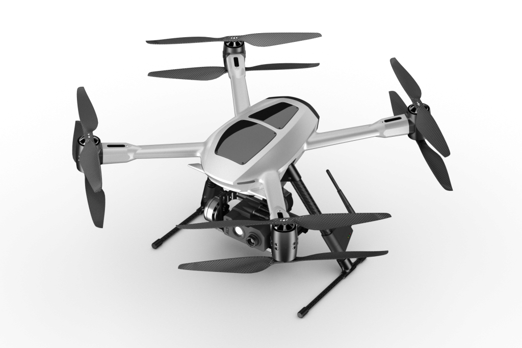
“Use of a UAV can help get real-time information to firefighters on the ground,” he said in a press release. “Just over the last few days we’ve seen more than a hundred fire starts in Washington. Additional information can provide a safer operating environment for firefighters.”  

The DNR frequently uses aircraft to track wildfires, but smoke and winds can ground airplanes and helicopters when they’re needed. The ScanEagle doesn’t need to worry as much about those inclement conditions, and that means there should be more accurate data flowing to firefighters on the ground more often.

According to the release, any decision to deploy the ScanEagle will be made in real time when fighting a fire, and will depend on the conditions at play.

The news comes after the Washington State Legislature voted to give the DNR the authority to deploy drones to monitor and suppress wildfires.

As previously reported, the use of drones have been banned in U.S. National Parks.

Previously on GeekWireWashington task force meets to discuss drone regulation


Blair Hanley Frank is GeekWire's Bay Area Correspondent. He has also worked for Macworld, PCWorld and TechHive. He can be found on Twitter @belril and can be reached by email atblair@geekwire.com.


fonte:FAA approves drones to monitor wildfires in Washington state - DIY Drones

Join Matternet! Let's change the world.

Join Matternet! Let's change the world.

 
At Matternet we are creating the next paradigm of transportation using networks of small flying vehicles.

We aim to impact millions of lives and empower individuals by bringing access to goods.

Our company is at a critical moment of product development and we’re looking for the most creative minds in technology to build the company that will define this decade. 

If you are exceptionally good at what you do and are passionate about changing the world get in touch (careers@matternet.us) and more info at matternet.us/work-with-us/


  • BRILLIANT MINDS WANTED.
  • FOR HAZARDOUS JOURNEY.
  • SMALL WAGES.
  • BITTER COLD.
  • LONG MONTHS OF COMPLETE DARKNESS.
  • CONSTANT DANGER.
  • SAFE RETURN DOUBTFUL.
  • HONOUR AND RECOGNITION IN CASE OF SUCCESS. 
 

Presented on TED on.ted.com/Matternet


fonte:Join Matternet! Let's change the world. - DIY Drones

Birth of a drone

Birth of a drone


He arrived yesterday and is still very underweight... But i must admit, he is very cute and flies like an hummingbird. I could not resist to share my happiness with the community. 


fonte:Birth of a drone - DIY Drones

mercoledì 16 luglio 2014

Dutch fire department announces purchase of Altura

Dutch fire department announces purchase of Altura

ALTURA-WHITE-FIRE-DEP
The Dutch fire department of Twente have today announced
their purchase of an Altura unmanned aircraft system from Aerial. Following their purchase the fire department have completed training, obtained all the required permits and attained the necessary certificates in the last couple of months.
The Twente fire department will now start with an initial trial phase, the results of which will be used to determine the added value of unmanned systems for fire departments in the Netherlands. Based on these findings the Minister of Security and Justice, Mr Ivo Opstelten, will decide whether other fire departments in the Netherlands could follow suit.
The Twente fire department expect to improve their operations by employing the Altura to explore fire grounds from above, assessing the origin of the fire with thermal imagery and composing an action plan based on aerial overviews. Additionally, the unmanned system could be used pro-actively by mapping hazardous sites to set an emergency plan in place. Furthermore, the Altura can also carry other sensors like a sniffer, which enables unmanned evaluation of toxin levels in the sky.
The fire department have purchased a basic Altura ATX8 set, consisting of an 8 motor system with a standard 868 Mhz- 2.4 Ghz diversity receiver, which was supplemented by a camera control premium upgrade and an Altura Dupla Vista camera box equipped with a daylight as well as thermal core.
The ATX8 is particularly suitable for safe, high intensity, emergency operations with large payloads due to its thoroughly tested failsafes and redundancy. Combined with the Dupla Vista camera box, this configuration allows the fire department to create aerial overviews with a daylight zoom core as well as a thermal camera in one flight. As a result, the rescue workers can acquire complete understanding of the premises within minutes. Moreover, the versatility of the Altura platform facilitates easy switching from camera payloads to sniffer payloads.
Aerialtronics will be working closely with the Twente fire department to assist in the use of their system, exploration of applications and possible innovation of novel payloads.
About Aerialtronics
Aerialtronics is a manufacturer of state of the art, high quality unmanned aircraft systems for civilian purposes. The company sells multirotor Alturas for a wide variety of applications in numerous countries worldwide. Aerialtronics’ systems are designed and developed in-house according to aviation grade quality standards making the Altura systems consistently reliable as well as stable. Aerialtronics defines the future of unmanned aircraft systems


fonte:Dutch fire department announces purchase of Altura | sUAS News

domenica 13 luglio 2014

Walkera H500 USA Edition (iUAS)

WALKERA NEWS: More development over the last 7 weeks while working through at AUVSI and with Walkera. We are please to announce the Walkera Tali H500 US Edition and their new iUAS division. We have included some photos of the final carbon black development. iUAS is a distribution and design center, a Walkera company designated to support selective products in the North American market. You can see their first releases at Amazon by August or September.. you never know... |more about iUAS, see their google+ page link here|


Tali H500: Professional grade, farther, longer endurance, HD 1080p, 3-axis gimbal (360 degrees), FPV and the new look!

The H500 with retractable gears, is an advanced unmmaned aerial video multi-rotor. Packaged to be Ready-to-Fly out of the box, it comes standard with multiple flight modes, such as Stabilized mode, Hyper IOC (Simple mode), Position Hold (Loiter) and One Key Return Home (RTL).


The H500 comes standard with 5400 milli-amps-hour 6S battery, providing you upto 25-30 minutes of flight time. This gives you sufficient time to survey a site, shoot a movie scene or conduct a virtual tour.


• 12 channels professional FPV Radio with OSD and Large 5" video screen

• 5.8G real time image monitor, 5”LCD screen

• Equipped with iLook+ HD Camera 1080p

• G-3D Brushless Gimbal

• Flight time up to 25 minutes (22.2V 5400mAh LiPo included)

• New GPS flight control system featuring more accurate position hold

• Hyper IOC - advanced intelligent orientation control

• Circle Mode - H500 can circle a GPS Waypoint to cruise around

• One Key Go Home

• Failsafe to return home in case of signal loss

• iLook+ Full HD 1080P Camera with built-in 5.8G Video Transmitter

• 3-Axis Brushless Gimbal (G-3D) supports iLook and Go Pro Hero 3 sized cameras

• MSRP (MAP) $1899 for the complete package. includes shipping within the continental USA, if ordered directly.


FPV Package: H500 unit with retractable landing gear/ DEVO F12E/Receiver/GPS/Flight controller/Motors/Batt/Charger/BL Gimble G-3D Gimbal/iLook+ camera(1080P)

Devo F12E with telemetry, GPS data (altitude, distance, coordinates), 3 battery voltage monitoring, 4 temperature monitoring and more (TBD: design challenge and alpha test: built-in SD Card recordings, updated Jul 10, 2014)


fonte:Walkera H500 USA Edition (iUAS) - The New Look - RC Groups

venerdì 11 luglio 2014

UDI U839 Nano 6 Axis 3D 2.4G 4CH Micro RC Quadcopter RTF - €30.21

UDI U839 Nano 6 Axis 3D 2.4G 4CH Micro RC Quadcopter RTF


Description:
Brand Name:UDI
Item Name: 6 Axis 2.4G 4CH RC Quadcopter
Item NO.: U839

Color Black&Orange
Frequency 2.4G
Channel 4CH
Control Distance 30m
Charging Time 40min
Flight Time 6 min
Battery 3.7V 150mAh Lipo
Battery for Transmitter 6 x 1.5AA (not included)
Dimension Aircraft: 45mm x 45mm x 45mm
Package : 140mm x 80mm x 200mm
Function Raise & Down/Forwards & Backwards/Left & Right Turning/Left & Right  Flying/Hovering/360 Degree Rotating


Features:
The 6-axis system allows the quad to be hand launched.
6-Axis gyro quad-rotorcraft flight, can easily implement various flight movements

2.4 technology adopted for anti-interference.Even more than one quadcopter is flying at the same time they will not interfere with each other.
Four highlight colorful LED lights,indicate direction in the night, also can increase the visual perception of flight.
Stronger wind resistance, strong stability,easier to control.
Super mini size, the smallest volume and the lightest weight,beyond imagination stability and operability.
The quadcopter can fly both indoor and outdoor.Including 4CH digital proportional RC system.


Package Included:
1 x Quadcopter
1 x Transmitter
2 x Battery
1 x USB Charging Cable
4 x Blade
1 x Protection Cover
1 x User Manual


fonte:UDI U839 Nano 6 Axis 3D 2.4G 4CH Micro RC Quadcopter RTF - €30.21

mercoledì 9 luglio 2014

OSRC on the Hack A Day contest

OSRC on the Hack A Day contest


Hack a Day has a very nice contest which i think goes well with the OSRC theme. Since in order to win there is nothing else but the support from the community and their votes, this is your chance to help the project by simply voting for it.


With the help of the Cash Prize i shall be able to make the system affordable for everyone and cut the price to half if not more than what is currently in the Pre-Order of the site.


I guess if the price is the only concern most people have with the system, this is the best option and seems the easiest to accomplish by just voting for it.


For those, unfamiliar with the project, you can check it out on its website at www.os-rc.com


A more detailed description can also be found in the Products Description.


FONTE:OSRC on the Hack A Day contest - DIY Drones

My 2 cents to the FAA

My 2 cents to the FAA


Not sure if anyone will ever read it, or anyone cares, but I commented here. If you haven't done so yet I encourage you to do so too:

http://www.regulations.gov/#!documentDetail;D=FAA-2014-0396-0001

To whom it may concern,

I am writing in response to the FAA's Interpretive rule for model aircraft. The proposed regulations are concerning to me as a hobbyist, photographer, and engineer interested in developing new technology. The specifics of the rule portray the FAA to be  ignorant of the hobby and acting out of retribution for the Piker V Huerta ruling. The proposal does little to improve the safety of air travel. Instead, it threatens to destroy a past time, stifle innovation, and squash entrepreneurship.

I have been involved in model aviation for nearly 20 years, and an AMA member for most of them. I grew up following the technological advances in this hobby and attribute much of my professional success as an engineer to skills and interests cultivated in this hobby. I worked summers in high school teaching kids model aviation and rocketry. I believe this hobby gave me a lot and can do the same for others, which is why I feel strongly about protecting it.

To many, including myself, the technology side of hobby is more exciting than actually flying. The advancements in electronic flight controllers, first person video, and new battery technology has given birth to a new era of innovators and hobbyists. The FAA's ban on video goggles is silly and misinformed. FPV flying has the potential to be a more accurate and safe way to fly model air craft than the conventional 'line of sight' method. Safe flight has nothing to do with FPV and everything to do with pilots acting responsibly and with care.

I also take objection to the FAA's strict ban on commercial flights under the guise of public safety. If a model aircraft pilot is paid to take aerial photographs of a location, how does that make it less safe than if if he or she were not paid? Why can professionally sponsored pilots not be paid, as they have been for years, for demonstrating their skills at controlled events? Do hobby and toy companies need a COA to test their products?

There needs to be a distinction between small hobby grade UAV for commercial use and large UAV used by our government. The two are not the same and should not be treated as such. A size or weight class exemption would be appropriate for small UAV commercial use.  UAVs have the potential to do great good and improve the safety of our airspace by doing things that would normally put a human operator in danger. The United States should strive to be a leader in this technology.

I suggest that the FAA work with hobbyists and entrepreneurs to develop common sense guidelines that preserves our country's safe airspace while protecting the rights of the model aviation community and encouraging growth of commercial UAV. I believe that the previous FAA advisory to model aircraft is appropriate:

1) Stay below 400 feet
2) Do not fly beyond line of slight range with the ground pilot
3) Stay away from developed areas

I would further suggest that size or weight classes be setup so there can be a distinction between small UAV and larger aircraft. Hobby grade UAV, be it used for commercial or recreational use, do not pose the same risk as aircraft that are orders of magnitude bigger. The FAA should recognize this and know which is appropriate to regulate.

By working with the community, the FAA can ensure that our country remains a leader in both air safety and emerging technology. I hope the FAA will revise their rule making based on feedback from the public.


FONTE:My 2 cents to the FAA - DIY Drones

domenica 6 luglio 2014

3D FPV camera The BlackBird

3D FPV camera The BlackBird


Hello! Today I want to tell You about the company's product FPV3DCam (fpv3dcam.com), a little and beautiful, you can say first of its kind - 3D video camera for fpv. 


And thus, meet - The BlackBird is the smallest and cool 3D video camera real time.


Let's begin the discussion with the appearance of The BlackBird. The BlackBird is the representative of a class without hull cameras and looks like a small box the size 34 x 34 mm, consisting of two video modules, connected by a two reliable 7 pin connectors. Such design allows to separate modules and change the length of stereo connecting them with connecting cable, as well as detachable design allows setting of convergence.


On the front of The BlackBird are two lens 3.6mm ( maybe 2.5 mm, depending on set of delivery, lenses standard M12), led - indicator, holders of lenses, which are hidden ultra compact high quality video sensors OmniVision OV7950 on the sensor 1/4" CMOS. The size of the array of pixels 656 x 492, image quality 470 TVL.


Rear 3D camera is a board to the locations of electronic components - all parts are soldered to the Board very efficiently and accurately. Also here is an interface connector to connect The BlackBird to the video transmitter (video glasses, monitor, etc) and voltage. By the way, the range of supply voltage camera from 5 to 12 volts, allowing you to use LiPo batteries 2S or 3S.


The outgoing video signal from the camera is transmitted in the format NTSC 525/60, 3D - Field Sequential 3D, which allows to use standard video transmitter in FPV system. And get in the video glasses quality Video in 3D, which allows us to more accurately navigate in space. The person using The BlackBird in FPV, feelings when managing rc model become more real, he feels the speed, volume, perform any complex maneuvers, becomes an easy game... you Can tell people use The BlackBird in FPV begins to look at this world with two eyes that originally given to him by nature.


FONTE:3D FPV camera The BlackBird - DIY Drones

Thriving South African drone community under threat from regs

Thriving South African drone community under threat from regs


Video from SteadiDrone, whose APM-powered QU4D we fly all the time and love

Robohub has a good report on South African drone community, which had enjoyed light regulation but is now facing strict rules:

A couple of years ago, while I was living in Cape Town, I met a group of people who were so into drones and aerial filming that they managed to initiate me into the world of UAVs. It turns out that South African soil is fertile ground for UAV enthusiasm and businesses. Therefore, I will dedicate this post to the thriving drone community of the Republic of South Africa.

Let’s start with the legislation: there is none. SACAA, the South African Civil Aviation Authority created confusion some two months ago, when it firstly declared a ban on the use of drones for aerial filming, and then issued this statement, which basically says that SACAA doesn’t ban something that is illegal already. The only problem is that it is not illegal, since there is no legislation covering the issue. Meanwhile, the Cape Town Film Commission has been in discussion with the SACAA, the Ministry of Transport, the Department of Trade and Industry as well as the Deputy Mayor of Cape Town, and has requested that the SACAA implement their model aircraft policy for use of the drones.

If approved, the policy will require adopting the below guidelines, which are similar to those used in Europe and Australia:

  • Flying only under 120m
  • No flying within 4.2 nautical miles of an airport
  • Flying only in line of sight of the operator (500m)
  • No auto pilot flying or night flying
  • No flying over public property and roads without permission
Meanwhile, filmmakers are still flocking to Cape Town to take advantage of the breathtaking scenery and skilled local aerial filming production crews.

Where drones are being used for filming, there is no doubt someone catering to their needs and providing them with equipment. SteadiDrone (see video above) is a proudly South African UAV manufacturer, founded in 2012 in the beautiful town of Knysna. Their flagship product is the QU4D, RTF quadcopter, which uses the APM 2.5 autopilot from 3D Robotics and is able to carry a GoPro camera on board.
Read the rest here


FONTE:Thriving South African drone community under threat from regs - DIY Drones

Agricultural mapping with the Penguin UAV and Pixhawk

Agricultural mapping with the Penguin UAV and Pixhawk


ben Boughtan has a great post on Ag Maps Online about his experience using Pixhawk and a Penguin UAV for crop mapping: 


Built with a 3DR Pixhawk (APM:Plane 3.0.2), Finwing Penguin 2815 fixed wing air frame, S100 Canon camera and RFD900 Radio (excellent Australian product), my budget agricultural unmanned aerial vehicle (aUAV) has kept me busy and learning lots in any spare time over the last few months.


In my last post, Unmanned Aerial Vehicles (UAV) in Precision Agriculture, I outlined the main components of a UAV for precision agriculture focusing on a fixed wing platform for collecting high resolution paddock scale data. In this followup post I will attempt to log some of my experiences. Note that this is just a learning experience – there are many commercial UAV options available for agriculture that are less time consuming and provide similar or better results right away.


Components


Platform


I needed a fixed wing platform that is readily available, cheap, with potential for long battery life, stability in the air and plenty of space for electrical components. I chose the Finwing Penguin. With the standard 2815 Finwing motor, 60 amp electronic speed controller (ESC), 9×6 propeller combined with a 4400Mha 3 cell Lipo battery I was only able to achieve about 20minutes flight time or enough to map about 40ha at 12m/s. I have a CXN engine mount which enables me to go to a 10″ prop which some of the gurus recommend. I could also increase my battery capacity and battery cell count to get longer flight time.


The Penguin is rather unique in its class as it has inbuilt landing gear. This consists of a pair wheels at the front and a single wheel at the back. I think this assists in preserving the plane when there is nowhere soft to belly land. The landing gear also allows you to take off like a traditional plane rather than hand launching. After making weight or centre gravity (CG) changes I will often take off from the ground. The downside is that these wheels to block up with mud quite easily if you land in a wet paddock.


The wings (including tail wing) come off for transport. I usually remove the main wings but leave tail wing in place as it is quite hard to get on and off due to awkward wiring and attachment arrangement.


The Penguin UAV does come with a pre-cut hole to install a down facing camera but it does not suit to place the camera top facing forward which is desirable. It was also very awkward to get the camera in and out as I had the Pixhawk autopilot installed above the camera position. I decided to go at the plane with a hacksaw and build a camera mount that would allow the camera to be installed from underneath the plane and also enough space to mount the camera top face forward.


S100 down facing camera mount and landing gear


Finwing Penguin UAV wings off for transport


UAV Finwing Penguin internal shot


Autopilot, GPS & Radio modem


As far as autopilot is concerned 3DR Pixhawk with APM:Plane 3.0.2 was the best option. At first I had issues getting my plane to fly well but once I upgraded to version 3.0.2+ the autotune feature changed the game altogether. This allowed the APM to adjust the PID settings in the plane as I manually flew it around. It works really well! During my latest flight I had an 8km/h cross wind that the APM was able to fly against successfully.


The GPS is a Ublox LEA-6M. It works well considering the price point. I did not attempt autonomous landing which is when GPS accuracy is more important. This GPS is able to get a fix within seconds of start-up and generally no issues throughout flight.


I initially used the 3DR radio modems but had all sorts of problems keeping a solid connection with my GCS. I decided to bite the bullet and buy a quality radio modem that should last me a long time and exceed all my range requirements. The RFD900 Radio pair is compatible with 3DR equipment and slotted in quite well. I did have to manufacture a cable to connect it to the Pixhawk and it took a bit of searching to figure which wires went where but I got it sorted within an hour or so. The RFD900 did have some driver issues on Windows. I had to install an old driver before I could get Mission Planner connected to the Pixhawk through RFD900. This all equates to time spent mucking around… BUT once working this product is excellent and I always have strong telemetry signal.


UAV actual flight path exported to Google Earth


Ground Control Station (GCS)


The Mission Planner software which runs on the ground station laptop allowing you to program the UAV and monitor it in flight is very good -  especially the Auto Waypoint Survey Grid feature. This allows you to draw the area you want to on the map. Simply load in a photograph from the camera you will be using and the target elevation. From this information is draws a flight path with your desired overlap.


Footprints Survey Grid
Mission Planner: Footprints Survey Grid


Mission Planner: In Flight Data


Ground Control Station


Sensor & Image Processing


Canon S100 is my sensor of choice as it is a great balance of quality, price functionality and size. I started with a Canon D10 but many of the photos came out under exposed. The S100 has a larger sensor and inbuilt GPS so it is a better choice for aerial mapping. The downside to the S100 is that the lens protrudes from the camera which exposes it to damage in a rough landing.


With UAV aerial mapping you need a way for the camera to trigger every few seconds on its own. With a Canon camera it is easy using the Canon Hack Development Kit (CHDK). This updates the camera firmware, allowing you to use intervalometer scripts to trigger camera every few seconds. CHDK also offers what seems like unlimited settings for the camera. It seems difficult to find a complete set of settings to use with CHDK, but for my next flight I will try using the DroneMapper documentation to setup CHDK.


In my last flight approximately 30% of my photos came out blurry. I discarded the worst of the photos but still had to use some poor quality photos to ensure the map had no blank spots. This is probably due to a combination of camera settings, camera mount and propeller slightly out of balance.


Using desktop software trial of Agisoft Photoscan I was able to product a 40ha orthomosaic. The application works surprisingly well considering all images are taken at slightly different angle and are only provided with one GPS point for each photo. It is a very computer intense process and if I was to do a significant amount of processing would need to upgrade my computer. Alternatively I could use DroneMapper, but my dataset did not meet their requirements because I had to cull some images. I hope to try DroneMapper next time.


UAV imagery : Suntop Wheat


I took my data a step further and set up a web server to host the data as tiles. You can check it out here. How to store and share data collected by UAVs is something I have been thinking about. An orthomosaic for a single paddock can be several gigabytes and take a powerful computer to view in its raw form. The web seems like a good way to display data having a server store the data and only send bits of the image that the end user requests as they zoom in and move around.


The S100 can be modified to collect NDVI data – check here for example.


Always learning the hard way


This is my second flying UAV. My first was a Finwing Penguin as well. I spent a couple days putting my plane together and all the components. It is a nervous time flying your brand new plane for the first time. The first time out my plane few OK in manual mode but since I am a very ordinary pilot I like to use assisted flying modes. I changed to Fly By Wire mode and due to a APM setting (that I had to set) the autopilot had reversed the elevator sending it crashing into the ground. This snapped the plane in half and bent up the fuselage. Thankfully this durable foam returns to shape when you put it in boiling water and the pieces can be glued back together, reinforced with carbon fiber and fiberglass tape. Now I follow the suggested checks in the APM:Plane instructions more closely.  I’ve had no crashes since but have landed in mud which can be painful to clean out of the landing gear.


Fuselage post crash on maiden flight


Conclusion


Putting together this UAV I have learned how all the components of a UAV fit together, challenges faced by the commercial suppliers, and a better understanding of the enormous potential on offer. I think the biggest challenge is not the UAV platform itself but collecting high quality consistent data that can be quickly processed and given a useful, profitable application. The setup I have discussed here not including laptop or the countless hours of time comes to about AU$1200. Obviously for mapping large areas on a consistent basis, a commercial UAV would be preferred or even essential.


UAV Finwing Penguin: Clocked up some hours


FONTE:Agricultural mapping with the Penguin UAV and Pixhawk - DIY Drones